Three interpolation techniques can be found under the menu item Modelling, in addition to the calculation of every layer and sketch body in the structure model:
¶ Calculate all layers

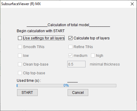
The main function of the SubsurfaceViewer is the calculation of all constructed and correlated geological layers with Delaunay triangulations. For this, associated lines in profile sections or structure maps should already been created and the layer distribution defined for the individual layers.
In addition, to calculate the geological layers, a triangulated surface must also be defined as a digital terrain model in the project settings. Otherwise you cannot use this function.
With a tick at checkbox use settings for all layers unavailable options for changes are opened. If the checkbox remains inactive, the calculation settings that have already been defined for each individual layer are selected. What the individual options mean and how you can adjust the calculation settings for layers can be found in this article: calculate model.
A progress bar shows how long the model calculation takes. In the info line Begin calculation with ... in the upper area the advanced layer is assigned. In case of a stagnation of the model calculation, errors for the respective layer can be checked. A log of the calculation is written to the info-window, so that you can also read here whether the calculation was successful for all layers.
Note: If you have created a digital terrain model (DTM) from a very high-resolution grid, then the calculation of the near-surface layers whose layer boundaries have a connection to this terrain model can take a very long time. So if you ever want to calculate an intermediate result during your modelling, it is recommended to use a lower-resolution terrain model first, so that you do not have to wait too long. You can read more about it in the section define layer distribution.
Note: This dialogue is called for a calculation of all layers in their order from top to bottom. So this calculation is basically (almost) always the last step to complete your conceptual layer model.
¶ 2D & 3D Kriging
SubsurfaceViewer offers 2D and 3D point kriging for interpolation of parameters for geological layer models. The implementation was project-specific and adapted to the needs of the users, so you will find an easy-to-understand tool for kriging in specific questions. The application does not cover the full range of possible kriging methods and options. If you need this, it is recommended to use a programme specialised in kriging. You are welcome to contact us if you feel that we should expand on this topic in our further developments.
You can find detailed information on kriging implementation here: 2D-/3D-Kriging
¶ Inverse Distance Weighting IDW
SubsurfaceViewer provides a tool for 2D inverse distance weighting interpolation of parameters for geological layer models. With this you can also create 2D Voronoi diagrams.
You can find detailed information on the Kriging implementation here: 2D-/3D-IDW
¶ 3D Inverse Distance Weighting
SubsurfaceViewer offers a tool for 3D inverse distance weighting interpolation of parameters for geological layer models. With this you can create 3D Voronoi diagrams.
You can find detailed information on the Kriging implementation here: 2D-/3D-IDW