In the SubsurfaceViewer you can filter data from geofactors, height patterns, voxel models and the parameter manager.
The filter function has the same structure everywhere, so we will demonstrate it using a voxel model as an example. You proceed in the same way with all other data types which you can filter.
The filter has geometric queries as well as queries on specific ranges of values. Since these queries can be concatenated with any number of AND and OR links, you can also make very complex queries with it.

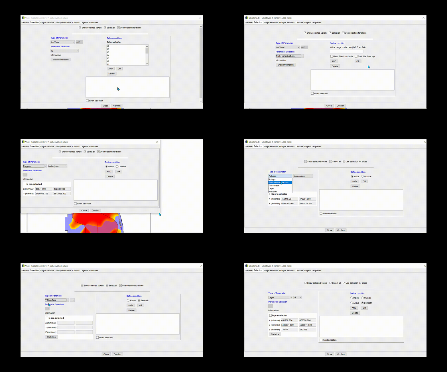
To see the filtering options select each category once in the Dropdown list under Type of Parameter and see how the user interface changes underneath.
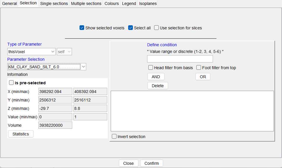
The general window structure looks like this:
Under type of parameter you select the data type. Next to it is another dropdown list that fills up if there are several objects of the same data type in the project. The field is inactive if the category thisVoxel or thisParameter is selected on the left. In this case, the parameter selection field is active and you can select the data series from the voxel model or the parameters with which you want to filter or whose Statistics you want to look at.
You will find the statistics field below. It contains geometric information for the selection. If the data set for the statistics query is very large, you must click the show information button. This prevents long waiting periods when operating the lists.
A tick by is pre-selected gives you the information whether a selected object has been filtered before. You use the filtered object for your query here. If you do not want this, you must deactivate the filter of the selected object beforehand. In this way, for example, polygons can be preselected from shapes and the query can be limited to these polygons. Raster data can be pre-filtered according to their values, and the selection takes place on the selected and visible raster contents. If you open the statistics window for data series, you will see the statistics of the (pre-)filtered data. The same applies to the geometric data.
On the right side of the window you will see the section define condition. Depending on the object and data type, the options change. They are described in the sub-chapters.
With the buttons AND and OR you add a condition with a corresponding link. It appears in the list below. You can delete conditions by selecting them in the list and pressing delete.
With invert selection you invert the current selection to your opposite.
Always confirm your filter with confirm.

¶ thisVoxel or thisParameter
These entries are only available for voxel models and parameters. Since several data series can be stored in these data structures, the list under parameter selection is filled with the titles of the data series when they are selected.
If the selected data series has a numeric data type but is not stored as an integer, fields become active that allow a value interval to be defined. You can see examples of the entries in the title above the input field. You can also define several intervals. You must enter them comma-separated. Multiple entries are always treated as an OR concatenation.
The options head filter from basis and foot filter from top are queries specifically aimed at vertical data development. With head filter from basis, the voxels are shown that contain the range of values specified above, but are not interrupted by values outside this range of values from the basis.
If you have a sedimentary sequence from sandy to finer towards the surface, and you want to know the depth below the top of the terrain from which you are sure to encounter only sand without interbeds towards the depth, then you can make good use of this application.
Foot filter from top is the reverse counterpart. You can use it if you like to know how deep the uninterrupted groundwater barrier layer extends and also extract a thickness grid .
If you have integers or text entries as a data series, a keyword list is generated on the right. You can select one or more entries from this list with the mouse and CTRL. Multiple selections are always treated as an OR concatenation. If text data was found, you have one field below the list with which you can enter word parts. If you only add the word part to the query, all entries containing this word part will be selected.
For voxel models you can load VOLEG, BELEG and PALEG legends. If these contain translations for the indices in the Alias column, the translations are displayed in the filter list. This only happens for the parameter that has been set as the colouring parameter in the Settings for the voxel model. This makes it easier for you to select indexed voxel content.
¶ Polygon
You can choose a geometry2D-object, a polygon-shape or the zoom-rectangle. The most recent zoom rectangle is always selected. If there is none, it is then filtered from nothing. You can choose between Inside and Outside for this filter option.
¶ Grid and Geofactors
Here all geofactors and height rasters are available for filtering. Since rasters are data series, you can select a value range of the raster as a condition in the field on the right. You do not filter the raster object, you only ask for the locations where the raster fulfils this condition. If you have already pre-filtered a raster, you may not need this input.
Raster data can always contain heights, which is why you have the above and beneath conditions to choose from in addition to the inside and outside conditions. Make a sensible selection here, tailored to your data.
¶ TIN surface
Select a surface from the loaded triangulations for the geometric query. To do this, select beneath or above.
¶ Layer
Here you query your data by means of a geological layer. The layer must have a layer top and bottom, otherwise they do not appear in the list. You can work with inside, outside, above and beneath conditions here.
Note that for borehole data with long depth intervals, those that intersect or touch the layer with a small interval section will be selected in an inside query. For an interpolation within a layer, this can have an influence. In our cases, this was desired. If you see a disadvantage, please contact us. Perhaps we can find a more suitable solution for you.
¶ Example
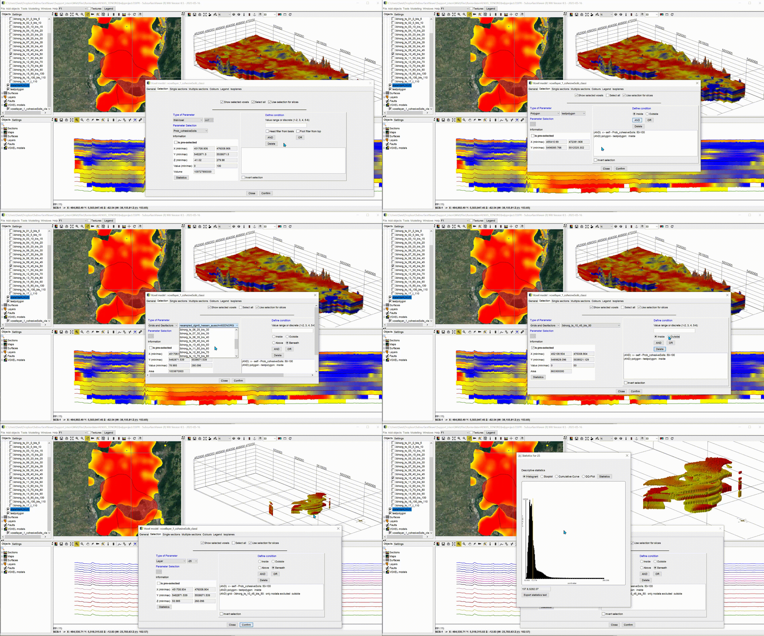
We have animated an application example for a complete filter procedure. This is freely chosen and is only intended to show the procedure.
The example shown is a voxel model generated from the depth slices of the 3D-NORG-project. It was provided by the Hessian State Office for Nature, Environment and Geology (HLNUG) for some illustrations and functional explanations.
